In The Bag

Friday 10, Saturday 11 January 2014

We start slowly, the weather couldn’t be more perfect, the distance a mere 30km.  Retracing our steps back to the kayaks, we laugh as we load.

This is IT… the day we “cross” Bass Strait, our time to land on the mainland of Tasmania.

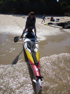
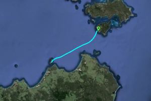
Our launch spot couldn’t be more heaven-sent, such a pristine place.  We follow the lines of the island for as long as we can, once we leave it there is little until we reach our destination, Bridport.  Wide open blue sky, flat wide blue sea – this is Bass Strait in another mood.  We spy a kayak and divert to have a chat with a local kayaker out on a fishing trip for the day.  I insist on a silly photo and video shoot, just to prove that Bass Strait isn’t all about life-threatening waves and intimidating winds.

The Furneaux Explorer tracks slighter closer to us to check us out as she heads to her home port of Bridport.

With such you-beaut conditions we head directly across Anderson Bay to Bridport, a long dune-backed beach to our left, Bass Strait shining to our right.  Finally, the gap closes and I spend those last ten kilometres reflecting on the past few weeks: the crossings, the challenges, the discoveries.  It has been quite an adventure.

We reach the busy beaches of Bridport and cruise along, hoping to find one without too many holiday-goers.  We choose one, luckily it turns out to be the beach closest to our contact’s home.

Driving the bow onto the wet sands, I cheer – Bass Strait crossed.

Bass Strait - crossed!

Bass Strait – crossed!

Jeff finds us, gathers us up along with all our gear, brings us to his home, shows us the hose and the clothesline, leaves us to unpack, sort and clean while he orders pizza and opens a bottle of chilled white – this is a man who truly knows sea kayakers and their needs!  Not surprising this, given Jeff is a Tasmanian sea kayaking legend who combines his love of photography with the ability to reach some remote and stunning locations.

We take a rest day with Jeff and are treated to a tour of north-east Tasmania – a local art gallery-cafe, a scenic lavender farm and the local club.

Waterhouse Island to Bridport

Waterhouse Island to Bridport

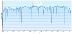
Paddling 30km to Bridport

Paddling 30km to Bridport

Crossing Bass Strait

Trip Days 18 & 19

Paddling Day 8

Friday 10 January 2014

Distance covered: 30km

Launched:

Landed:

Rest day: Saturday 11 January 2014

Westward Ho!

Thursday 9 January 2014

From Clarke most sea kayakers cross the notorious currents of Banks Strait, finishing at Little Musselroe Bay in remote north-east Tasmania.  We had set Devonport as our goal.  Despite the extended stay on Flinders, we still had plenty of time to head that direction.  Instead of coming out of Spike Cove and continuing south, we pointed our bows to the west and took aim for an island 50km away.

Madness!

I did consider this plan totally daft.  Why volunteer for yet another long open water crossing with no possible landing when we could reach Tasmania in half that distance?  There’s no logical answer to this, other than it was there, and we could do it.  Weather conditions allowed it, we had sought and received permission to land on the island ahead, and personally, I knew I was up for it.  After everything I had already done, I was confident in my ability to sit in the kayak seat for a 50km crossing.

Calculations had determined that 11 o’clock was the best time to depart, the tide turning our way.  Yet we were ready and eager to leave by 10 o’clock so off we set.  The GPS reveals a slight bow in our path, caused by the tides sucking us back in the wrong direction.  It didn’t matter, the winds were blowing from behind and we let loose our sails.  The waters of Banks Strait proved an interesting place to kayak, occasional tidal races appearing with white caps offering more challenging moments.

There’s not a lot to see out there.  The wind farms on Cape Portland provided a marker against which to note our passage, then the land disappears further into Ringarooma Bay and we continue, ever onwards until we arrive on the only beach on the island.  Harry strips all off and dives into the wind-blown waves in a mad moment of delight while I wander looking for a campsite, observing the resident Cape Barren geese.

This place is a special slice of heaven and we are most grateful to the owner for sharing it with us.

Clarke to Waterhouse

Onwards from Clarke Island

Onwards from Clarke Island

Crossing Bass Strait

Trip Day 17

Paddling Day 7

Thursday 9 January 2014

Distance covered:

Launched:

Landed:

Island-hopping

Wednesday 8 January 2014

This was a short day, yet nonetheless it seemed to bring a range of paddling challenges.  Crossing from Cape Barren towards Preservation Island and then crossing to Clarke Island meant we would encounter a number of tidal flows and needed to be aware of which way the tides where headed.

There were serene sections passing by sculptural rocks; there were challenging sections where the white waters could have been due to reefs or to tidal flows and we had to work out which as we moved closer.  There was a tidal flow off the south-west of Preservation that brought me back to my experience in the Gulf of Corryvrecken (Scotland) and finally there were the lichen-coated majestic rocky shores of Clarke Island and the calm waters of  Spike Cove.

With hindsight, I wished we’d planned the day differently and actually landed on Preservation Island and had a closer look at Rum Island.  Having read more of Matthew Flinders’ adventures in this area, and the tale of the wreck of the Sydney Cove, walking the sand and land of these places would have been a special treat.

A sunny afternoon in Spike Cove allowed for wandering and rambling, limited by the dense bush which, despite its low height, proved quite impenetrable.

Cape Barren Island to Clarke Island

Cape Barren Island to Clarke Island

Crossing Bass Strait

Trip Day 17

Paddling Day 7

Wednesday 8 January 2014

Distance covered:

Launched:

Landed: